All vocabulary words are underlined.
1. Geography

What is Geography? It is the study of the land, people, weather, culture, and other features of our planet.
2. Continent
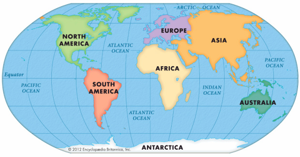
About 70% of the Earth's surface is covered in water. The rest of surface is dry land. There are some very large pieces of land, usually separated by oceans or seas. These are called continents. There are 7 continents on our planet.
In your notebook, can you write the continents in order, from largest to smallest in size?
If you were absent on September 12, this is an activity we did in class. Download it and print it out.
| contienents_scramble.doc |
3. Landform

A landform is a feature of land or water on Earth's surface. Some examples of landforms are: mountains, lakes, rivers, oceans, canyons, volcanoes, islands, and many more.
4. Maps

A map is a drawing of an area of land. There are many different kinds of maps that have many different uses. People who study Social Studies use maps to understand where and how people live.

A political map shows where different countries are. Other political maps show how a country is broken up into states or provinces.

A weather map shows what the weather is like in a particular place. A weather map can show a country, a state, a city, or any other type of area.

A road map shows where the roads are in a particular place. People use road maps when they are driving cars through a place. Road maps can show a city, state, country, or any other type of area.

A symbol map uses symbols, or small pictures, to show information about a place. A symbol map can show where natural resources are, where certain animals live, where different cultures are found, or many other things. These types of maps can show a state, country, or other any other place.
5. Parts of a Map

A map legend, or key, gives you all the information you will need to understand the map. It usually shows the symbols you will see on the map and what they stand for. The legend may also show the scale of the map. The scale is like a ruler that you can use to measure distances on the map and compare them to real distances on the ground.
5. Compass Rose

The compass rose is found on most maps. It tells us the cardinal directions, or main directions, as well as the intermediate directions, or in between directions.
What are the 4 cardinal directions?
What are the 4 intermediate directions?
6. Latitude and longitude lines

People have drawn an imaginary grid pattern over the map of the planet to help them .


